
Dateline: Bhubaneswar | November 19, 2026
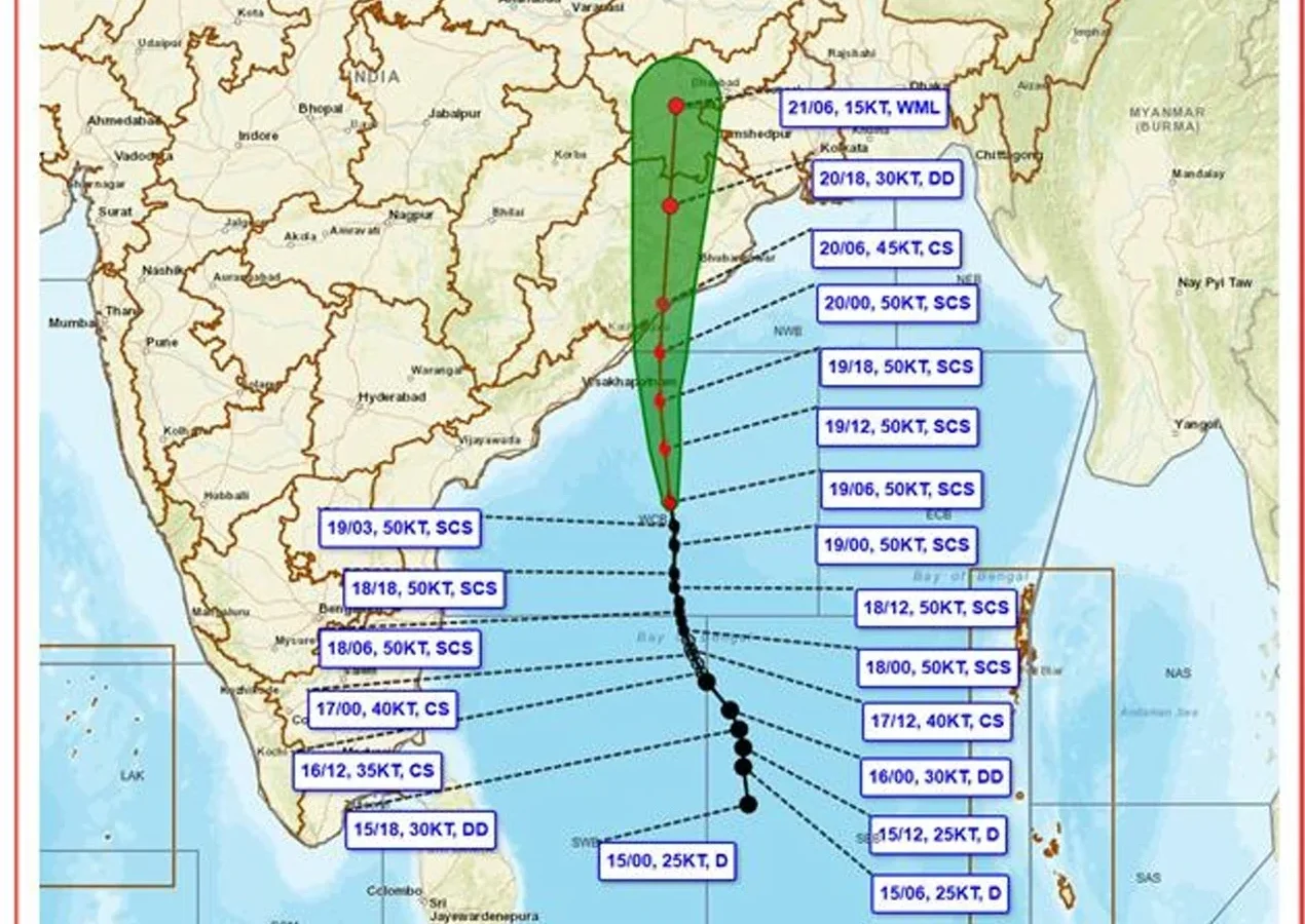
Bhubaneswar, Odisha 19 Nov 2026: Severe Cyclonic Storm Akvan is advancing towards the Odisha coast over the westcentral Bay of Bengal, raising concerns across coastal and southern districts. According to the India Meteorological Department’s (IMD) press release issued at 3 PM on November 19, 2026, the system is likely to cross the North Andhra Pradesh and South Odisha coasts between Narsapur and Puri, close to the east of Gopalpur, by noon on November 20. The cyclone is expected to bring maximum sustained winds of 90–100 kmph, with gusts reaching up to 110 kmph. The weather system has not made landfall yet, and residents have been advised to follow official weather warnings and local administration instructions.
Contents
- Current Position and Movement of Cyclone Akvan
- Possible Landfall Near Gopalpur on November 20
- Heavy to Extremely Heavy Rainfall Forecast Across Odisha
- What Can Bhubaneswar and Coastal Odisha Expect?
- Odisha Government Intensifies Cyclone Preparedness
- Fishermen and Coastal Residents Advised to Remain Alert
- Safety Advisory: What Residents Should Do
- The Road Ahead: Next 24 Hours Crucial for Odisha
Current Position and Movement of Cyclone Akvan
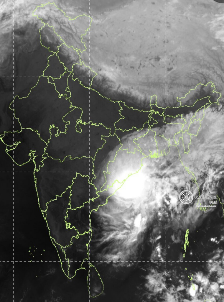
According to the IMD’s latest available detailed position report, at 8:30 AM IST on November 19, Severe Cyclonic Storm Akvan was centred over the westcentral Bay of Bengal near latitude 14.9°N and longitude 85.3°E.
At that time, the system was approximately:
- 420 km southeast of Narsapur in Andhra Pradesh.
- 400 km south-southeast of Kalingapatnam in Andhra Pradesh.
- 490 km south of Gopalpur in Odisha.
- 550 km south of Puri in Odisha.
- 590 km east-northeast of Chennai in Tamil Nadu.
The cyclone has been moving in a north-northwestward direction, bringing it closer to the eastern coastline.
These distances represent the cyclone’s reported position at the specified observation time and should not be interpreted as its current distance. Its location and movement may change with subsequent observations.
Possible Landfall Near Gopalpur on November 20
The most significant development in the latest forecast is the possibility of Akvan crossing the coastline close to Gopalpur.
The IMD expects the cyclone to move north-northwestwards before crossing the North Andhra Pradesh and South Odisha coasts between Narsapur and Puri, close to the east of Gopalpur, by noon on November 20.
The expected wind conditions during the crossing are:
- Maximum sustained wind speed: 90–100 kmph.
- Maximum gusting wind speed: Up to 110 kmph.
The anticipated landfall zone places southern coastal Odisha among the areas requiring particular attention. Ganjam and neighbouring coastal regions could experience strong winds, intense rainfall and disruptions to normal activities.
However, the exact point and timing of landfall remain subject to changes in the cyclone’s movement. Residents should not interpret the forecast location as a confirmed landfall point.
Heavy to Extremely Heavy Rainfall Forecast Across Odisha
Rainfall is expected to be one of the major impacts of Cyclone Akvan.
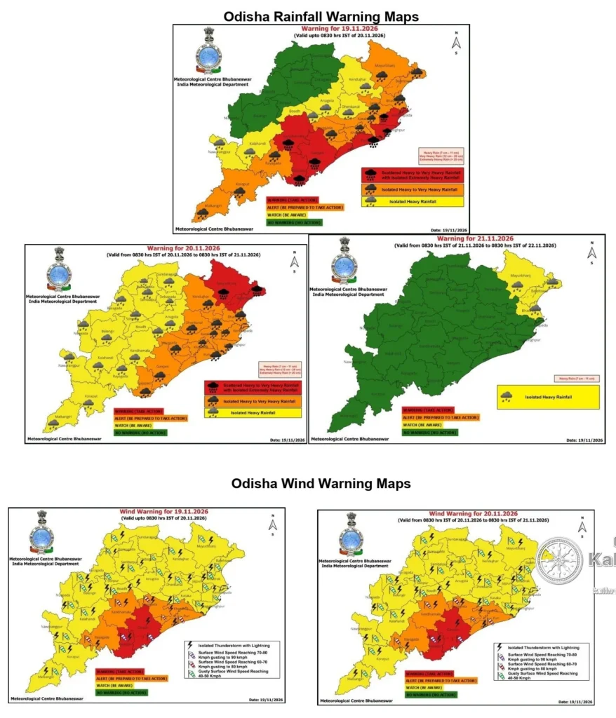
The IMD’s November 19 weather bulletin warns of isolated extremely heavy rainfall over Odisha during November 19 and 20. The system is also expected to generate thunderstorms and strong squally winds across affected areas.
Southern Odisha and coastal districts are likely to experience significant weather activity as the cyclone approaches.
Districts including Ganjam, Gajapati, Puri, Jagatsinghpur, Kendrapara and Kandhamal have been identified in reports concerning red-category rainfall warnings. Orange and yellow warnings have also been reported for other parts of the state. Warning categories and affected districts should be checked against the latest district-specific IMD bulletin, as they can change with updated forecasts.
What Can Bhubaneswar and Coastal Odisha Expect?
The approaching weather system may also affect the daily lives of residents in Bhubaneswar, Khordha, Puri, Cuttack and other coastal areas.
Heavy rainfall could cause temporary waterlogging, traffic congestion, reduced visibility and disruption to local transportation. Strong winds may damage trees, temporary structures, electric poles and overhead cables.
Urban areas with poor drainage could face localised flooding during periods of intense rainfall.
Residents in low-lying areas, particularly those living close to rivers, canals and drainage channels, should remain alert to changing weather conditions.
People should avoid unnecessary travel during periods of heavy rain and strong winds. Particular caution is necessary around construction sites, trees, electric infrastructure and vulnerable buildings.
Odisha Government Intensifies Cyclone Preparedness
With Akvan approaching the coastline, the Odisha government has intensified preparations to minimise potential damage and protect lives.
Chief Minister Mohan Charan Majhi reviewed the state’s cyclone preparedness at the Special Relief Commissioner’s control room on November 18. The government directed departments and district administrations to strengthen emergency response arrangements and prioritise public safety.
According to the Chief Minister’s Office, 448 cyclone shelters had been made operational, while more than 47,000 people and 1,313 pregnant women had been evacuated to safer locations at the time of the November 18 update.
The government also reported the deployment of 74 rescue teams and the release of an advance amount of ₹20.5 crore for relief and rescue operations. Senior officers were assigned responsibilities for monitoring preparedness in vulnerable districts.
In a subsequent update reported by Akashvani on November 19, nearly 72,000 people had been shifted to safer locations. Around 7,900 cyclone shelters were reported ready, with 60 Odisha Disaster Rapid Action Force teams, 14 National Disaster Response Force teams and 131 fire service teams deployed for emergency operations.
These preparations reflect the administration’s effort to ensure timely evacuation, rescue operations and relief support in vulnerable locations.
Fishermen and Coastal Residents Advised to Remain Alert
Marine conditions are expected to deteriorate as Cyclone Akvan approaches the coastline.
The IMD’s coastal weather bulletin has advised caution along the Odisha coast and instructed ports to maintain Local Cautionary Signal No. III.
The sea is expected to remain very rough to high along the South Odisha coast. Rain and thunderstorms are also forecast across coastal areas.
Fishermen should strictly follow official restrictions and avoid venturing into the sea until conditions are declared safe.
People living in coastal villages should follow evacuation instructions issued by district authorities. Families should keep essential supplies ready, including drinking water, dry food, prescribed medicines, flashlights, batteries and mobile phone charging arrangements.
Safety Advisory: What Residents Should Do
As the cyclone approaches, residents are advised to take the following precautions:
- Follow official IMD bulletins and district administration announcements.
- Avoid unnecessary travel during severe weather conditions.
- Stay away from trees, electric poles, overhead wires and damaged buildings.
- Move to designated cyclone shelters if instructed by local authorities.
- Keep important documents, medicines, drinking water and emergency supplies ready.
- Fishermen should not enter the sea during the warning period.
- Avoid spreading unverified cyclone information through social media or messaging platforms.
Residents should also ensure that elderly people, children, pregnant women and persons requiring medical assistance have access to safe shelter and necessary support.
The Road Ahead: Next 24 Hours Crucial for Odisha
The next 24 hours will be particularly important as Severe Cyclonic Storm Akvan approaches the eastern coastline.
With the IMD forecasting a possible landfall near Gopalpur by noon on November 20, the southern coastal belt remains a major area of concern. Heavy rainfall, strong winds and possible localised flooding could disrupt normal life in vulnerable areas.
The effectiveness of government preparedness, timely evacuation and public cooperation will play an important role in minimising potential damage.
Kalinga Bani will continue to follow official IMD bulletins and government announcements to provide verified updates on the cyclone’s movement, rainfall warnings, landfall developments and emergency arrangements.
Stay alert. Follow official advisories. Stay safe.
| Parameter | Details |
|---|---|
| Cyclone Name | Akvan (AKVAN) |
| Current Classification | Severe Cyclonic Storm |
| Current Location | Westcentral Bay of Bengal |
| Forecast Landfall Date | November 20, 2026 |
| Possible Landfall Zone | Between Narsapur and Puri, close to east of Gopalpur |
| Expected Sustained Wind | 90–100 kmph |
| Maximum Wind Gusts | Up to 110 kmph |
| Heavy Rainfall Warning | November 19–20 |
| Official Weather Authority | India Meteorological Department (IMD) |




Leave a Reply